Day
16. Ochoco National Forest to Brownlee Campground US Forest
Service Idaho |
Miles
today = 175 Total miles = 3820 |
| What
a wild ride today. 6 hours of mostly canyon carving part of which
was through Hells Canyon. I suppose if I looked at the map I'd really
be able to figure it out but I'm out of Cambridge on ID 71 by about
20 miles maybe. Its hard to tell, once I crossed into Idaho it was
slow going up a road along a reservoir for the power company and I'm
beat. I didn't get as far as I wanted too but my options were limited and since I crossed back into the Mountain Standard Time zone I thought Heck why not. I'm not sure why none of my maps have the campgrounds for the US forest service but they are very nice. Rustic of course, this one was a gravel road uphill that was packed at least so I wasn't going to kill myself. Of course going downhill in the morning will be another fete. But all in all I'm right next to a babbling brook on one side, the "road" and then another site and then a stream all in the V of a canyon. Which means that if there is a rainstorm uphill I won't have to worry about the ride out in the morning. The weather is absolutely amazing. I've got a great tan line going across my face where my visor is. It’s 5:11 and it is probably still in the high 70's. Though I am sure it will get cold again tonight, it was in the low 40's last night. There are some patchy high clouds so it is just beautiful. It is certainly peak fall foliage here with the yellow leaves on all the trees. So the trip...From where I was last night into Mitchell the road was twisty in the crisp morning air. Mostly rugged rocky high desert warm grays with relaxed curves in the canyon. Very little traffic in the middle of nowhere so I was able to open it up since I knew it would be slower going through the mountains. If I remember correctly, Mitchell to John Day was more of the same but sharper turns and less trees. A few places were picturesque but on the bike my eyes were glued to the road, which caused a curtailing of stopping for pictures. There were some fossil beds as noted by the signs but really nothing popped out until I got past John Day and into Baker City. Baker City has a very nice downtown that really contrasts with any city I've seen since I don't know when. It has an established downtown that hasn’t been deserted for the usual Wal-Mart sitting outside of town to save on taxes. It had nice bungalow and prewar houses and just nice over all, a kind town that could be called Mayberry. Now, going out of Baker City to the Idaho state line was absolutely incredible. I might as well have been on Mars. I quickly crossed over the Oregon Trail, the Rockies were visible in the northeast but otherwise it was scrub brush for as far as the eye can see. I cannot imagine the amount of faith the settlers were traveling on because I would have been devastated to come out of the mountains to a desert landscape that only had thick scrub brush and no trees to offer. It rolled for miles and miles. I soon entered the west end of the area surrounding Hells Canyon. I started out behind a big rig for wildfire fighting, I assume heading towards northern Idaho, but they let me pass even though they were far enough ahead and drove like…firefighters, I guess. Most of the road caused me to slow down to at least 10 over the posted curve speed limits/suggestions, which is a pretty good indicator of a comfortable speed to take curves. If it is posted over 40, and if I am on top, of things 20 over is possible. Just depends on how wide the shoulder is, what it is made of, how close the guardrail is to the edge of the road, if there is one and if opposing traffic is present for ego instability. There was evidence of a forest fire in the recent years toward the Idaho side of the canyon but there were hardly any trees to begin with except for the aspen and poplars along the stream that the road followed. It was all very picturesque with the yellow cottonwood trees and the farmhouses nearby tucked neatly in-between the canyon walls. Into Idaho along the west side of the river was relatively easy going. Once I got past the huge earthen dam and switched sides it was slow going along the reservoir and by that I mean constant hairpin curves rated at 20 mph. Which is why when you take the road test for a motorcycle license you do slow speed turns, well that and U-turns in the street, because coupled with the lack of a guard rail and the usual drop-offs it can be quite unnerving if you start thinking about your own mortality and how easily flesh is shredded from the body by sharp rocks. It really took some nerve for me to ignore the few vehicles that passed from the opposite direction to go as much as possible because they could have surprised me more by their sudden appearance as I was rounding in and out of the curves along the canyon walls above the reservoir. My total concentration was needed here to link all my turns. Being away from city folk my irritability only surfaced once or twice. I actually had to pump my own gas at the Shell station in Baker City. It was strange, I slowly took off my helmet and gloves, unlocked the tank cap, looked around for the likes of a pump monkey and with great hesitation I reached for the nozzle and started to fill my tank. I guess it was far enough out of the way they didn't worry about anyone seeing the lack of an attendant. Or maybe being on a motorbike they didn't even bother coming out to hand me the nozzle. The cashier inside never said a word about it. I had planned to stop at a grocery store in Cambridge, ID, which is further up the road, so it is tuna helper again. Which is okay because it calls for less than half the amount of meat that hamburger helper does, even as I cut back on it, so it’s easier to make and eat all of it instead of having leftovers to deal with. Did I mention it is hunting season here? Up the road a ways here in the campground, of nine sites, is a group from Oklahoma that have a couple of beautiful birddogs. Walking up to get water, a pick-up truckload of hunters and dogs came down from the upper end. The hunting thing had me more worried last night since it is prime deer cover, which was proven this morning when I stepped out of my tent and scared away a buck and his posse of two does that were within 25 yards of my tent. But I only heard one far off gunshot maybe a half-hour before I left. It was odd seeing all these boats being pulled everywhere out here in the desert, even in Washington, but then you get to a dammed section of a river and you can see that not only is it the only action for miles around, they are big lakes that go on for miles. It’s just an odd thing to see boats in the desert but here in Idaho all along the reservoir there are campers along the edge boondocking alongside their boat trailers. In the morning it’s a call to the BMW dealership in Boise to see if they have a tire and/or a call to the Sturgis dealer. I think I have enough tread to make Sturgis but if that is the case I might as well make it all the way back home because the road is flat and straight out the Black Hills of South Dakota. Granted with the canyon carving of late as long as I keep a good line through the curves I don't get as much of an abrupt transition from the worn flat section of my tire |
 |
||||||||||||||||||||||||||||||||||||||
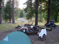
My
nice site in the Ochoco Divide Campground. |
|||||||||||||||||||||||||||||||||||||||
 |
|||||||||||||||||||||||||||||||||||||||
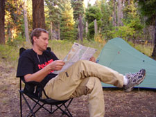
"But
Alaska is only four inches away." |
|||||||||||||||||||||||||||||||||||||||
 |
|||||||||||||||||||||||||||||||||||||||
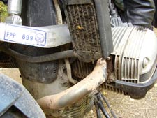
Most
of that is still from that road construction in Montana. A monsoon
on the moon might get that off.... |
|||||||||||||||||||||||||||||||||||||||
 |
|||||||||||||||||||||||||||||||||||||||
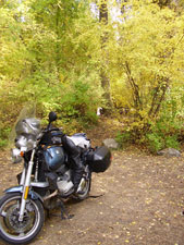
My
site in Brownlee was quite well hidden in the trees which were at
peak autumn colors. |
|||||||||||||||||||||||||||||||||||||||
 |
|||||||||||||||||||||||||||||||||||||||
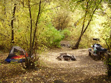
Inside
the trees showing my site in Brownlee. One of my better sites on
the trip. |
|||||||||||||||||||||||||||||||||||||||
|
|||||||||||||||||||||||||||||||||||||||
click
on images to view larger |
||||||||||